Everything below comes from the public record: the applicant's own filings, county agency review letters, the 2006 Damascus Master Plan, and school and traffic data. Where something comes from a community meeting attendee's account rather than a document, we say so.
1. Overview
The short version
107 units proposed at 26134 Ridge Road; every claim below sourced to the document it comes from
A developer wants to build 107 apartments on 4.73 acres at Ridge Road in Damascus. The usable land is closer to 2.96 acres, which puts the effective density near 36 units per acre, roughly 81 percent above the master plan's town-center guidance of 15 to 20.
The county file contradicts itself on the basics: 107 units or 123, who the applicant is, who owns the land. The traffic study's headline conclusion rests on numbers that never appear in its pages. The noise study's model was tuned with speeds above the posted limit. The schools are over capacity, the bus runs weekdays only, and the $55 million financing exists only on paper. Each section below lays out one piece, with the source for every claim.
2. Design flaws
36 units an acre where the plan says 20
107 units on about 2.96 usable acres, roughly 81% over the master plan's town-center guidance
The application covers 4.73 acres. But acreage on a cover sheet and buildable land are different things. At a community meeting in 2025, the applicant's own engineer acknowledged that the usable portion of the site is about 2.96 acres, and a stream buffer takes more. Divide 107 units by 2.96 acres and you get roughly 36 units per acre.
The 2006 Damascus Master Plan, the document that governs what gets built in the town center, sets residential density guidance at 15 to 20 dwelling units per acre: 20 in the outer town center, 15 in the inner core. Thirty-six is roughly 81 percent above the top of that range. Even on the full 4.73 gross acres, the project would land near 23 units an acre, still above the plan's guidance.
The plan also contains a safety valve the county has in its pocket: at the time of subdivision or site plan review, the Planning Board may limit development below what the zoning allows, to keep scale, height, and proportion compatible with adjoining neighborhoods. The zone maximum is not a promise. It is a ceiling, and the board can lower it.
Master plan guidance, town center (15-20 du/acre)
20
Proposed project, effective density (107 units / ~2.96 usable acres)
36
Dwelling units per acre. Bars scaled to the project's effective density of about 36.1 du/acre. The usable-acreage figure of 2.96 acres is the applicant team's own acknowledgment at a 2025 community meeting, an attendee account.
Source: 2006 Damascus Master Plan, printed pp. 97 (density table), 13 (small-town framework), 22 (compatibility provision). The 2.96-acre usable figure and the density math come from a community meeting attendee account: the applicant team's engineer acknowledged the 2.96-acre figure during discussion. The applicant's filing states 4.73 gross acres.
Design flaws, continued
A suburban apartment bar on a town-center site
County reviewers: proposed open space does not meet code; facades flagged; 8 fire-access corrections
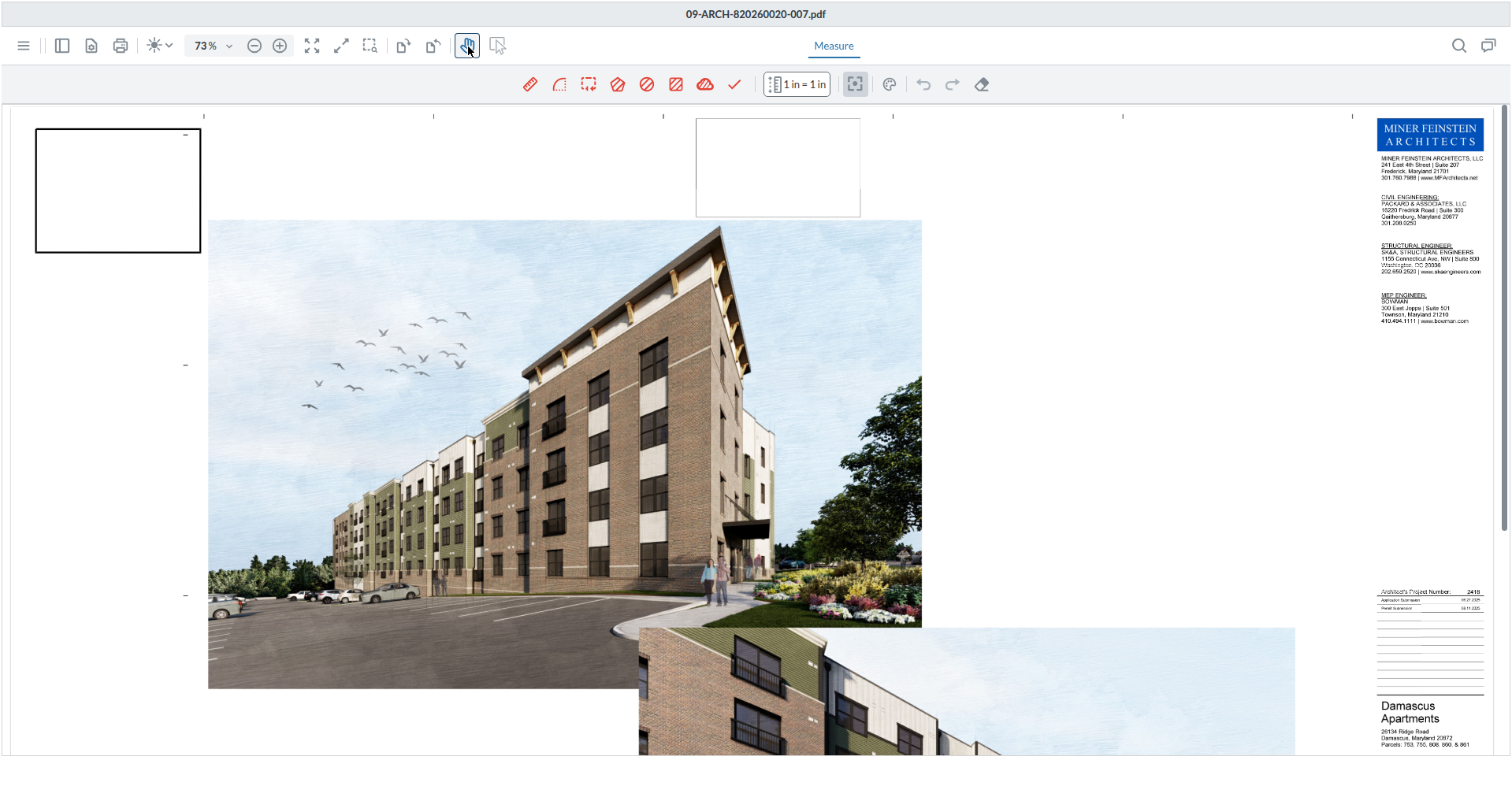
The architectural drawings, prepared by Miner Feinstein Architects and dated November 2025, show a contemporary four-story apartment bar: double-loaded corridors, reddish-brown brick and fiber-cement siding, flat parapet roofs, Juliet balconies, the building fronting Ridge Road with surface parking lots to the side and rear. It is, in typology, a suburban garden apartment complex.
The master plan asks for something else. The town center is to have "compact town-scale intensity." Zoning should emphasize "proportion, design, and an architectural context of structures." New development near single-family neighborhoods must be reviewed for "scale, height, and proportion," and transition areas should "replicate the scale, design and pattern of historic small town residential neighborhoods." A 55-foot apartment bar at the maximum height the zoning allows answers none of that.
The county's own reviewers agree something is off. The design reviewer flagged the long facades and materials. Three separate county reviewers told the applicant the proposed public open space does not meet the code's definition or design requirements. The code requires 19,670 square feet; the applicant's exhibit shows 3,287 on site, about one-sixth. Montgomery Parks staff said they were willing to explore a payment in lieu of on-site open space, while noting concerns about the suitability of the Damascus Neighborhood Park the applicant proposed, and that other options would need to be identified. Eight separate corrections from Montgomery County Fire and Rescue, covering hydrants, apparatus access, and walkable grade around the building, went months without resolution.
The applicant's rendering, from the filed plans (sheets 007, v1, 11/12/2025, Miner Feinstein Architects). Renderings are drawn to flatter: this one shows the building on a sunny day, viewed across its side parking lot. The building fronts Ridge Road, with surface parking to the side and rear. Four stories, 55 feet, the maximum the zoning allows.
Source: 09-ARCH-820260020-001 through -007.pdf (Miner Feinstein Architects, v1, 11/12/2025); DRC comments, January 2026 (Marie LaBaw, Fire and Rescue, 8 items; Roberta Duke, design staff; Darcy Buckley, Montgomery Parks; Carlos Pazmino and Mark Beall on parking); 2006 Damascus Master Plan, printed pp. 1-3, 14-22, 23-26.
3. Paperwork
107 or 123 units? The file can't agree with itself
97 filings reviewed; contradictions on unit count, ownership, sewer category, and watershed
Start with who is applying. The applications name Olympus Real Estate LLC, with Brian Gallagher as the contact. But the traffic study's scoping form, signed by county planning, transportation, and state highway staff, names a different developer entirely: "Brian Kim; AGC - Damascus, LLC." The project's noise study is addressed to Brian Kim at AGC's Fulton office and states that AGC contracted the work. The architectural cover sheet lists AGC - Damascus, LLC of Fulton as the developer and calls the project "Damascus Apartments." The county record does not explain the discrepancy.
Then there is the unit count. Every application says 107. But the traffic scoping form says "up to 123." The forest conservation notice letter says "123 unit residential multifamily apartment building." The forest conservation sediment plan says "123 UNIT RENTAL APARTMENT COMPLEX." Nobody reading the file can say with certainty which number the project is.
The applications disagree with themselves on basic facts. The statements of justification say the sewer category is S-1; every plan cover sheet says S-3. Some sheets place the watershed in Class I-P; others say Class III-P. The site plan application lists its filing date as "829," with no year. The forest conservation application references "Preliminary Plan 120250070," a different case number. A sight-distance evaluation form, the document that certifies drivers can see safely out of the driveway, was filed completely blank: no plan number, no project name, no signature, no seal. Some developer certificates were filed unsigned, and one signature reads "Brian Gallasher."
On ownership, the forms tell two stories. On the preliminary plan application, Brian Gallagher signed but left all three capacity boxes (sole owner, authorized representative, contract purchaser) blank. On the site plan application, he checked "the sole owner of the subject property." The application's own owner section, two pages earlier, names "Harry H Burdette Et Al." State land records agree: the Burdette heirs own the property. On the second extension request, the form checks "Owner" for Olympus Real Estate LLC while listing its affiliation as "Contract Purchaser." This is not a finding of wrongdoing. It is a file that contradicts itself on who is applying, how many units are proposed, and who owns the land.
The technical reports are no cleaner. The noise study's computer model failed to match actual field measurements, so the speeds on Ridge Road were raised to 38 mph to force a match, above both the measured speeds and the posted 30 mph limit. That 38 mph was then carried into the 2045 forecast "to be conservative," even though the county's highway plan sets a 25 mph target speed for Ridge Road at the site. The report argues the site falls under both the 55-decibel county noise standard and the 65-decibel highway corridor standard, then concludes without ever saying which one applies. Its traffic growth rate was derived by comparing a 2008 count at Bethesda Church Road with a 2025 count at Kings Grove Way, two different places seventeen years apart. And like the traffic study, it is addressed to Brian Kim at AGC-Damascus and calls the project "Damascus Apartments."
Source: 00-APP-120260020.pdf, 00-APP-820260020.pdf, 00-APP-F20250430.pdf; 16-TIS-120260020.pdf (scoping form naming Brian Kim; AGC - Damascus, LLC); 32-NOISE-820260020.pdf (HUSH Acoustics, 14 pp., dated 10/30/2025; addressed to Brian Kim, AGC - Damascus, LLC; project called "Damascus Apartments"); 17-SIGHT-820260020.pdf (blank form); 01-SOJ applications (sewer category); DAIC documents #31, #67, #78, #84, #41, #61. Ownership facts per Maryland SDAT tax records for 26134 Ridge Road and the application's own owner section.
4. The applicants
Two developers, one project, no explanation
Applications name Gallagher and Olympus; the technical studies name Kim and AGC-Damascus
The applications name Olympus Real Estate LLC, with Brian Gallagher as the contact, and the county's project page lists Gallagher as contract purchaser. But the traffic study's scoping form, the noise study, and the architectural cover sheet all name Brian Kim and AGC-Damascus, LLC of Fulton, and call the project "Damascus Apartments." Dean Packard of Packard & Associates is the engineer of record. The county record does not explain the discrepancy.
Traffic study dated 10/27/2025; counts from 9/26/2024; no county sign-off after 9 months
The traffic study is 54 pages from Gorove Slade, a respected Bethesda transportation firm. Its conclusions are clean: three intersections analyzed, all passing, no mitigation required. Its foundations are less clean. The traffic counts were taken on a single Thursday in September 2024, two years before the study would matter to a planning board. The two large townhome developments built along Ridge Road in 2023 through 2025, with 109 units between them, do appear in the background traffic, but the trip estimates borrowed for them come from old analyses, one dating to 2015.
Then the study starts arguing with itself. Its trip-generation table is built on 107 units and subtracts credit for the existing 3,410-square-foot office building, producing a net increase of 39 morning trips and 38 evening trips. But the text states three times that the capacity analysis used "up to 123 units," without ever showing the 123-unit numbers. It also states that "since the existing site is currently vacant, the full trip generation of the proposed development was added to the road network rather than the net new increase." The site is not vacant. There is an office building on it, in poor repair, with food trucks, sheds for sale, a bus, and tractor trailers across the lot. A reader cannot tell whether the intersection results reflect 107 units or 123, net trips or full trips, a vacant site or an occupied one. That means the study's headline conclusion, every intersection passing with no mitigation required, rests on an analysis whose inputs never appear in its own pages.
The study's bicycle section has its own problem. It correctly notes that the county's Bicycle Master Plan designates separated bike lanes on Ridge Road along the site frontage, then describes their location as the "north side" of the roadway in the text and the "south side" in its deficiency tables. Ridge Road runs north-south; the plan designates the lanes two-way on the east side, between Main Street and Bethesda Church Road. The study then concludes the planned lanes are not feasible for lack of right-of-way and proposes extending a sidepath along the frontage instead, while conceding that right-of-way also prevents an adequate sidepath north of the property line.
And the document itself shows signs of assembly from other jobs. Its improvement tables evaluate a "Retail Store Curb Cut," a "Hardware Store Driveway," and a "Shopping Center Driveway," none of which exist at this residential redevelopment of a small office property. One page footer reads "Sunday, October 27, 2025." That date was a Monday. The introduction sites the project at "26314 Ridge Road"; the cover says 26134. The text claims 44 morning and 43 afternoon net new trips; the trip tables say 39 and 38. The executive summary says the project "will remove the existing buildings"; a later page says it will "improve" them. Two printed pages are numbered 5, two more numbered 7, and page 6 is skipped entirely.
Meanwhile the county's transportation review has gone quiet. In January 2026, transportation staff told the applicant it owed a $2,000 review fee and that the traffic statement and storm drain were "currently under review." Nine months later, no approval, no revised study, no fee receipt, and no state highway decision on the single curb cut onto Route 27 appears anywhere in the public record. The September extension memo lists every outstanding issue in the case and never mentions transportation at all.
Source: 16-TS-120260020.pdf (Gorove Slade, 54 pp., dated 10/27/2025, filed to DAIC 12/31/2025; counts 9/26/2024; bicycle sections pp. 5, 8, 39-40, 44, 50); Montgomery County Bicycle Master Plan (adopted December 2018), Damascus bikeway recommendations (Ridge Rd: separated bike lanes, two-way east side, Main St to Bethesda Church Rd); 16-TIS-120260020.pdf (scoping form, filed 1/5/2026); MCDOT DRC comments 1/23/2026 (Marie LaBaw; Carlos Pazmino: $2,000 fee owed, LATR incomplete, under review); Montgomery Planning Extension Memo No. 2, September 2026. The current condition of the site (food trucks, sheds, bus, tractor trailers, for-lease sign) is from an October 2026 on-site observation.
6. Schools and infrastructure
The schools are full. The bus doesn't run Saturdays.
Damascus ES at 126% of capacity; Baker MS at 111% with portables; Route 90 runs weekdays only
Damascus Elementary School is operating at about 126 percent of its program capacity: 338 students in a building programmed for 269. John T. Baker Middle School is at about 111 percent, with portable classrooms out back. These are not projections. They are this year's numbers, from the school system's own facilities plan. The county is planning a replacement high school because the cluster is outgrowing its buildings.
The old school-capacity moratoria are gone; the county now uses a surcharge system instead, and none of the surcharges are triggered here. That does not change the classrooms. The county's own annual school test shows a cushion of only 7 seats at Damascus Elementary against a projection of about 13 new elementary students from a project this size, and that projection assumes the site feeds Damascus Elementary, which the records do not confirm.
The town has one bus. Route 90 runs from Damascus to the Shady Grove Metro station, weekdays only, roughly every half hour starting around 5:15 in the morning. There is no Saturday service. About 1.5 percent of Damascus commuters use transit, and the county's own assessment ranks the Germantown-Damascus corridor among its worst transit areas. The county's planning data puts about 2,500 jobs in the larger Damascus policy area against nearly 9,850 working residents, and an independent check of Census business data found 258 establishments employing 2,155 people in the 20872 ZIP code, an average of about 8 workers each, with no anchor employer. Sixty-two percent of workers drive alone; the average commute is 37.6 minutes.
The applicant team has said (per attendee accounts) 123 parking spaces for 107 units, about 1.15 per unit, meets the minimum. Seventy-one of the units would have two or three bedrooms. There is no street parking on Ridge Road, where daily traffic runs around 22,000 vehicles, and the project has a single curb cut. None of this means working families should not live in Damascus. It means a 107-unit development whose residents will overwhelmingly need cars, whose children will need classrooms, and whose workers will need jobs elsewhere is being placed in the part of the county least equipped to absorb it.
Source: MCPS FY2027 Capital Improvements Program (Damascus ES 338/269; Baker MS 819/741, 2 relocatables; Damascus HS 1,322/1,409, projected 1,501/1,409); FY27 Annual School Test (effective 7/1/2026; Growth and Infrastructure Policy; no UPP surcharge triggered); Ride On Route 90 schedule; M-NCPPC Round 10.1 forecast (2,500 at-place jobs, Damascus policy area, 2020); Census ZBP 2023 (20872: 258 establishments, 2,155 employees); ACS 2020-2024 (Damascus CDP commuting); SHA AADT (~22,000 near Damascus). The 123-space figure and the 2.96-acre figure come from community meeting attendee accounts.
7. The money
Every dollar is still on paper
$3.5M projected state funding ("not a reservation or commitment"); $33M in proposed bonds, none issued
The project is proposed as 100 percent affordable, for households at or below 60 percent of area median income, financed with 4 percent federal Low-Income Housing Tax Credits paired with tax-exempt bonds. The tax credit program does not give developers cash. It gives them tax credits, which they sell to corporate investors, generating equity that covers roughly a third of development costs. The rest comes from bonds and gap loans.
Here, the gap financing is projected as $3.5 million from the state's Rental Housing Works program. That figure appears in the state's pipeline report with estimated closing in April 2027, accompanied by the standard disclaimer that the listing "is not a reservation or commitment of funds." A February 2026 state notice proposed up to $33 million in private-activity bonds naming AGC Ridge Road LP as the owner-operator. No bond issuance has been found in any public record since. The total development cost in the state pipeline is about $55 million.
The vocabulary, briefly
The financing discussion runs on acronyms. Here is what they mean, and how they stack in this deal.
LIHTC (Low-Income Housing Tax Credit). The federal program, created in 1986, behind most income-restricted apartments built in America. It does not give developers cash; it gives tax credits, which developers sell to corporate investors to raise equity. There are two kinds: "9 percent" credits, awarded competitively and covering roughly 70 percent of a project's costs, and "4 percent" credits, available non-competitively to projects financed with tax-exempt bonds, covering roughly 30 percent. This project proposes the 4 percent kind. In Maryland the credits are allocated by the state housing department, DHCD, and every unit must stay income-restricted for at least 30 years.
MPDU (Moderately Priced Dwelling Unit). Montgomery County's own inclusionary program. Developers of new housing must price 12.5 to 15 percent of units below market, generally for households earning around 65 percent of area median income, and in exchange they receive a density bonus allowing more units than the base zoning. This project is unusual: instead of a set-aside inside a market-rate building, all 107 units are proposed as MPDUs, and the density bonus is what helps make 107 units possible on this site.
Tax-exempt bonds. The proposed $33 million in private-activity bonds. Pairing a project with this kind of bond financing is what unlocks the 4 percent credits. Bonds are debt, not a grant; they get repaid from project revenue.
Rental Housing Works. Maryland DHCD's gap-financing program: subordinate public loans that fill the hole between what the credits and bonds cover and what the project actually costs. The $3.5 million figure is a projection in the state's pipeline report, explicitly "not a reservation or commitment of funds."
Workforce housing. A separate county program for households earning above MPDU levels. It is not part of this proposal's financing, though the terms get used interchangeably often enough that the distinction is worth making.
Stacked together, the deal is: MPDU status earns the density bonus; 4 percent credits plus $33 million in bonds supply roughly two-thirds of the $55 million cost; a projected $3.5 million state gap loan helps close the rest. Every layer depends on the layers beneath it, and every layer is still on paper.
Meanwhile, a commercial building permit for the address sits "in process" declaring a $30.7 million construction value, filed before the plans it would build have been approved. The tax credit program has well-documented criticisms, and they deserve attribution: a federal accountability review found per-unit costs going unmonitored; academic analysis has estimated developers capture around half the subsidy; tens of thousands of units nationally have left affordability restrictions through legal exit provisions. None of that is an accusation against anyone in Damascus. It is context for what the program is: a system that can produce genuinely needed housing and genuinely profitable deals at the same time, with the public's ability to tell the difference depending entirely on scrutiny.
Source: Maryland DHCD Rental Housing Works pipeline report 12/31/2025 ($3.5M projected; "not a reservation or commitment of funds" disclaimer); DHCD RHW status report 9/1/2026 (estimated closing Apr-27); DHCD legal notice 2/20/2026 ($33M private-activity bonds proposed; AGC Ridge Road LP named owner-operator); Montgomery County DPS commercial building permit 1135656 ("in process"; $30,739,440 valuation). Program criticism attributed to GAO-18-637 and published academic analysis.
"The Applicant needs additional time to develop design changes that are intended to achieve better master plan compliance and compatibility, as well as to provide the required open space on site."
The applicant's own words, Extension Request No. 2, filed September 2026